
A Cedar City community
Living in Cedar Trails.
Cedar Trails is an early-stage master-planned community of more than 480 acres along Cedar Boulevard, the road Cedar City renamed from Old Highway 91 in 2025 because this project controls most of that frontage. It runs south from the Main Street area past Cross Hollow Road near Exit 57 to Tipple Road at the city limits. Read it as a plan in motion, not a finished neighborhood: what is recorded, what is listed today, and what still needs confirming.
I am Scott Buehler, a Southern Utah resident of 20-plus years and a licensed REALTOR and lender. This is the honest version of what Cedar Trails is right now, pod by pod, and what I would check before you buy land or a home on this corridor.
New to the area? Start with the Cedar City guide, then come back for Cedar Trails.
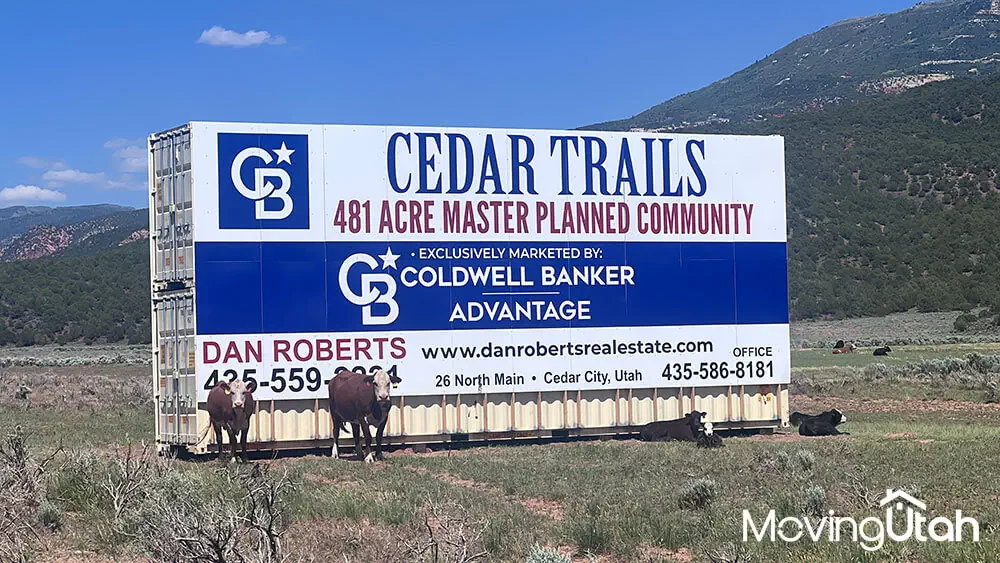
Cedar Boulevard, south of Main St to Tipple Rd
Cedar Trails.
Current listings
Homes and land in Cedar Trails.
Fed straight from the MLS and limited to the Cedar Trails corridor. Because this is an early-stage plan, what shows up here may be land or development parcels before finished homes start listing, and anything that sells drops off the same day.
No homes available? Be sure to check out all Cedar City listings.
Want the map view? Open the full Cedar Trails search. Selling instead? Start with what your home is worth.
Listing information comes from the local MLS and is deemed reliable but not guaranteed.
On this page
Life in an early-stage plan
Read this one as a plan, not a finished street.
Cedar Trails is the biggest south-side idea on Cedar City's books right now, and it does not live the way a finished subdivision lives. It is a corridor plan: commercial frontage along Cedar Boulevard with residential pods behind it, moving through the city's review process one piece at a time. Some buyers here are looking at future homes. Others are looking at land, phasing, utilities, and what the next pod might do to the block they are considering.
The location is the reason the plan matters as much as it does. Cedar Boulevard, the road Cedar City renamed from Old Highway 91 in 2025, runs south from the Main Street area, through the Cross Hollow Road corridor near I-15 Exit 57, to Tipple Road at the city limits. Cedar Trails controls most of that frontage, which is exactly why the city agreed to the rename. That puts this corridor squarely in Cedar City's south-side growth path rather than the older downtown grid.
The opportunity and the caution are the same fact: it is early. You want to know which pod a parcel sits in, what has actually been approved versus what is only sketched, and what timeline the city or a builder can document. I pull that from planning records and the live MLS, not from a sales flyer.
Corridor highlights
The details worth checking first.
Six things make this corridor its own place: the scale of the plan, the pod-by-pod structure, the road that carries its name now, quick access to I-15, a real trailhead on the same corridor, and a market that is still mostly land.
Over 480 acres
Cedar City planning records describe Cedar Trails as more than 480 acres of commercial and residential parcels, a far bigger footprint than a typical subdivision, which is why it builds out pod by pod.
Numbered pods, not one plat
The plan moves through the city in pods. The Ridge at Cedar Trails vicinity plan, near 1900 South Ken Middleton Parkway, has included a roughly 57-acre pod for around 50 single-family lots off Church Street, with neighboring pods sketched as townhome-style development.
Cedar Boulevard runs through it
Cedar City renamed Old Highway 91 to Cedar Boulevard in August 2025, in large part because Cedar Trails controls roughly 80 percent of that frontage. The road is meant to work as a commercial spine, similar to how Main Street functions downtown.
Exit 57, minutes away
I-15's Exit 57 interchange, at Cross Hollow Road, sits a short drive north along Cedar Boulevard. That is the same interchange that feeds Providence Center's shopping and Cedar City's business loop.
Shurtz Canyon Trailhead on the same road
Continue south on Cedar Boulevard past Tipple Road and you reach Shurtz Canyon Road and its BLM trailhead, part of the Iron Hills Trail System. It is a real, named trail on the same corridor, not a brochure amenity.
Still mostly a land market
Planning records on individual pods date back to at least 2023, and the road rename only happened in 2025. Treat any specific parcel's build timeline as unconfirmed until you see the recorded plat and current construction status.
Homes, land & pods
The pod is the unit of comparison here.
Cedar Trails is not yet the kind of community where you can study ten finished resales and understand the market in an afternoon. Right now a lot of what changes hands is land and development parcels, not move-in homes. That tells you about the stage of the plan, not about what a finished house will eventually sell for.
The clearest example of what is actually moving is the Ridge at Cedar Trails vicinity plan near Ken Middleton Parkway, where city records describe one pod at roughly 57 acres zoned for around 50 low-density single-family lots off Church Street, with neighboring pods sketched for townhome-style planned unit development. Pod numbers, acreages, and product types can change as each piece works through city review, so treat any figure here as a snapshot, not a promise.
As a buyer, your due-diligence list matters more than any brochure. Ask what pod the property sits in, what has actually been approved by the city versus what is only a concept, what utilities are in, what roads are finished, and what uses are planned on the parcels around it. I will help you pull every one of those answers before you commit.
At Cedar Trails, the pod number is part of the price.
Once finished homes do start listing in real numbers, I will compare them pod by pod and product by product rather than averaging the whole corridor. A single-family pod off Church Street, a townhome-style pod, and commercial-fronting land near Cedar Boulevard should never be valued with the same yardstick.
Trails & outdoors
A real trailhead at the end of the same road.
The name "Cedar Trails" describes the development, not a footpath through it, so I want to be precise about what outdoor access actually exists. The honest answer is that a genuine BLM trailhead sits a short drive further down the same corridor, not inside the plan itself. Here is the real tiering, from the corridor's own road to a day trip.
Shurtz Canyon Trailhead (moderate)
From Exit 57, head south on Cedar Boulevard about 2.4 miles to Tipple Road, then left 0.6 miles to Shurtz Canyon Road, then 0.7 miles to the trailhead. It has gravel parking, a vault toilet, and a kiosk, with 20-plus miles of built singletrack and more planned.
Iron Hills Trail System (moderate to hard)
Shurtz Canyon feeds into the broader Iron Hills Trail System, a National Recreation Trail with more than 30 miles of interconnected singletrack on BLM land south of town, popular with mountain bikers, hikers, and trail runners alike.
Coal Creek Trail, in town
The paved Coal Creek Trail follows the creek across town, a short drive north via Cedar Boulevard and Main Street, for a flatter walk or ride that does not require the trailhead drive.
Cedar Breaks and Brian Head, day trip
Farther out, State Route 14 climbs to Cedar Breaks National Monument, seasonal and roughly 35 to 40 minutes up, and Brian Head's ski runs sit about 40 minutes north via Parowan.
Trail directions and mileage come from the BLM's Shurtz Canyon and Pyramid Ridge trailhead pages. The wider outdoor picture, Cedar Breaks and Brian Head included, is in the Cedar City guide.
Errands & drive times
The practical drive map.
These are approximate estimates measured from near the Cross Hollow Road and Cedar Boulevard area, roughly the middle of the corridor. Confirm door-to-door timing from the exact pod or parcel you are considering, since the corridor runs a couple of miles north to south.
| The errand | Where it happens | From Cedar Trails |
|---|---|---|
| Freeway on-ramp | Interstate 15 at Exit 57, Cross Hollow Rd | ~5 min |
| Full grocery and big-box run | Providence Center, off Exit 57 | ~7 min |
| Second grocery option | Smith's Food & Drug, 633 S Main St | ~9 min |
| Hardware and home improvement | The Home Depot, Providence Center | ~7 min |
| Healthcare | Cedar City Hospital, 1303 N Main St | ~12 min |
| Historic Main Street | Downtown Cedar City | ~10 min |
| Campus and events | Southern Utah University | ~11 min |
| Mountain biking and hiking | Shurtz Canyon Trailhead | ~8 min |
| Flights | Cedar City Regional Airport (CDC) | ~13 min |
Cedar Trails sits on the south side of Cedar City. That means fast access to I-15 and Providence Center, plus a shorter run toward Kanarraville and the Kolob Canyons entrance of Zion, roughly 25 minutes south, than you get from north Cedar. The full regional map lives in the Cedar City guide.
Schools & education
Schools, by the facts.
Cedar Trails is within the Iron County School District, which operates the district's south-central Cedar City schools including South Elementary (grades K-5), Cedar Middle School, and Cedar High School. Because Cedar Trails is a brand-new, early-stage development spanning a couple of miles of frontage, I would not assume a single school assignment for every pod without checking the parcel address.
The district is also redrawing boundaries on a published timeline: six elementary boundaries change for the 2026-27 school year, and both middle and high school boundaries change for 2027-28. Confirm the current and upcoming assignment for any specific address directly with Iron County School District, and use independent sources such as GreatSchools and Niche for your own review of the schools themselves.
I cover the bigger education picture, including SUU, in the Cedar City guide.
Why the road changed names
Cedar Trails renamed a highway.
Here is a fact that tells you how much weight this project carries locally: Cedar Trails is the reason a state highway got a new name. Old Highway 91, the frontage road that had carried through-traffic south from Main Street toward Kanarraville for decades, was renamed Cedar Boulevard by the Cedar City Council in August 2025, covering the stretch from around Main Street down to Tipple Road at the city limits. The Utah Department of Transportation had relinquished ownership of that section to the city.
The rename was not cosmetic. The project's representative told the council that roughly 80 percent of that road frontage sits inside the Cedar Trails plan, and that the intent is for Cedar Boulevard to function as a commercial corridor the way Main Street does downtown, not just a bypass. The council approved it, with one member voting against.
What that means for a buyer or seller is straightforward: this is a corridor being built around commercial frontage first, with residential pods layered behind it. If quiet, purely residential streets are what you want, ask specifically how far a given pod sits from the Cedar Boulevard frontage before you commit. If you want a corner near future retail and services, the frontage lots are the ones to watch.
What I check before I call a Cedar Trails parcel a safe bet
- Which pod the parcel sits in, and whether that pod has a recorded, approved plat or is still a concept.
- How close the parcel sits to Cedar Boulevard frontage versus an interior residential pod.
- What utilities, roads, and improvements are actually installed versus planned for a future phase.
- Current zoning and use on the specific parcel with Cedar City's planning department, not a brochure.
Sources: Cedar City Council and Planning Commission records, and local news coverage of the Cedar Boulevard rename.
What locals know
The stuff a plan map does not tell you.
Early corridor developments ask better questions from buyers than finished neighborhoods do. These are the ones I would keep on the table for Cedar Trails.
-
Recorded beats rumored. A recorded plat, approved use, or signed improvement agreement carries more weight than a sales flyer or a rendering.
-
Pod edges matter. A lot on the edge of today's pod may back tomorrow's road extension, a commercial pad, or a different product type entirely.
-
The corridor is built for commercial first. Cedar Boulevard frontage is meant to fill in with retail and services over time. Expect construction and traffic to change as that happens.
-
The trailhead is a drive, not a walk. Shurtz Canyon is a real destination on the same road, but it is further south past Tipple Road, not inside every pod.
Buy or sell here
The buyer side and the seller side.
Buying in Cedar Trails
Cedar Trails is a master-planned community along Cedar Boulevard, the road Cedar City renamed from Old Highway 91 in August 2025 because the Cedar Trails project itself controls roughly 80 percent of that frontage. The corridor runs south from around Main Street near the Maverik and Golden Corral, down through the Cross Hollow Road area by Exit 57, to Tipple Road at the city limits. That puts Cedar Trails on the south side of town, along the freeway-facing edge rather than the older downtown grid.
No, and that is the most important thing to understand before you shop here. Cedar Trails is genuinely early-stage. Cedar City's planning records show it moving through the process in numbered pods, for example a Ridge at Cedar Trails vicinity plan near 1900 South Ken Middleton Parkway with a roughly 57-acre, 50-lot single-family pod alongside neighboring pods planned for townhomes. Confirm the current phase, recorded plat, and construction status of any specific parcel before you treat a plan as a finished neighborhood.
The plan mixes commercial frontage along Cedar Boulevard with residential pods behind it. The pod that has moved furthest through the city process called for single-family lots off Church Street, and neighboring pods were described as townhome-style planned unit developments. Product type, lot size, and builder can all change pod by pod, so confirm what is actually approved and being offered on the parcel you are looking at.
There is not yet a settled finished-home price range, because most of what changes hands here is land and development parcels rather than move-in resales. I price any home or parcel against the live MLS and the exact product and phase being offered, not a broad neighborhood average. Tell me what you are considering and I will pull current numbers.
Ready to look? See what is on the market or tell me what you are after.
Selling in Cedar Trails
Value depends on the property's pod and phase, its recorded approvals, utility and road status, and whether it is land, a finished home, or a development parcel. I price it from the live MLS and the recorded details, not from a broad neighborhood average. Start with the home valuation page and I will run a real comparison, no obligation.
List with me and your property is featured right here on this Cedar Trails page, on the Cedar City hub, and in the listing paths buyers use while they research south Cedar City. The get featured page walks through exactly how that works.
It depends on your property's pod, its approvals, and what competing land or builder inventory is active right now. Tell me your timeline and I will compare the live supply, your recorded property details, and current buyer demand, then give you a straight read on price instead of a pitch.
Yes, and timing the two is mostly a sequencing problem across your sale, your next purchase, and any financing. I cover the playbook in the buy and sell at once guide. On any single purchase I take one role only, and the full choice-of-provider explanation is linked below.
Thinking about it? Start with your number or see how featuring works.
Keep exploring Cedar City

Want a closer look at Cedar Trails?
Buying, I can help you separate what is recorded from what is only planned, pod by pod. Selling, I will position the property around its pod, its approvals, and the current live competition instead of a lazy corridor-wide average.
Selling in Cedar Trails
Want to sell your home in Cedar Trails? List it with Scott Buehler and get featured on MovingUtah.
Cedar Trails is still early stage, moving through numbered pods and phases, so pricing here means confirming the exact plat and approvals on a specific parcel rather than comparing it to a finished neighborhood.